


Signposting, topoguides and GPS tracks
Planning a cycling trip or adventure along the Veloscenic cycle route? Here are three services available to ensure you don’t lose your way.

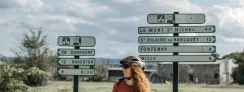
Signposting in place along 98% of the cycle route
The cycle route is, at time of writing, almost entirely signposted from the Ile de la Cité in central Paris to the Bay of the Mont Saint-Michel. All along the route, you’ll spot the Veloscenic logo, set on green signs, sometimes giving the number of kilometres to the next stage.
Of the two alternative sections proposed between Massy and Rambouillet, only the alternative section via Versailles and Saint-Rémy-lès-Chevreuse is signposted along the whole way. The other alternative section via Limours should be fully equipped with signs in the course of 2023, making the Veloscenic a 100% signposted cycle route! In the meantime, you can still ride along this alternative section with ease by downloading the GPS tracks for the stages Limours - Saint-Arnoult and Saint-Arnoult - Rambouillet.

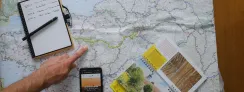
One topoguide published in English and two French ones updated in 2022
Veloscenic: Paris - Versailles - Mont-Saint-Michel (Richard Peace, Excellent books) is the only dedicated guidebook in English for the moment. There is also a new German guidebook (2025) in the renowned Bikeline cycling route collection by the publisher Esterbauer.
We can also recommend two relevant French topoguides, updated in 2022 and published by Éditions Glénat and Ouest France. These offer comprehensive coverage, including detailed maps, advice on finding your way and enjoying visits and tours, cultural and historical information on the towns and countryside you cross, plus listings of specific Accueil Vélo accredited accommodation available along each stage.

Download the cycle route tracks
Keep to hand precise details on the cycle route by making use of a mobile app offering detailed guidance, downloading GPX tracks covering the entire cycle route, or then a specific stage, going via the dedicated page.


